We use cookies to improve your experience on our website. Cookies help us remember your preferences, analyze how you use our site, and provide personalized content. By clicking "Accept All," you consent to the use of all cookies. You can also customize your cookie preferences or reject non-essential cookies.
If you are a Swelleye PRO subscriber and want to access live streams, you must enable cookies and accept at least "Strictly Necessary" cookies.
For more information about our cookie usage, please read our Cookie Policy.
A typhoon is a tropical cyclone that forms in the Western Pacific Ocean. These powerful rotating storm systems develop over warm ocean waters (above 26.5°C / 80°F) and are characterized by:
Formation Process: Typhoons begin as tropical disturbances, intensifying through a feedback loop where warm, moist air rises and condenses, releasing heat energy that fuels further development. The Coriolis effect from Earth's rotation causes the system to spin.
The same phenomenon is called a "hurricane" in the Atlantic / Eastern Pacific and a "cyclone" in the Indian Ocean. Only the regional name differs.
The Western Pacific has the most active typhoon basin in the world, with typhoons possible year-round and an average of 16 per year. However, activity varies by season:
Climate Influences: El Niño and La Niña cycles affect typhoon tracks and intensity. El Niño years tend to shift storm formation further east, while La Niña can bring more systems closer to Asia's coastlines. Long-term warming trends may also influence storm intensity and rainfall.
Taiwan's position in the Western Pacific puts it directly in the path of many typhoon tracks. Common patterns include:
Steering Currents: The subtropical ridge and mid-latitude westerlies influence track direction. Monitoring pressure patterns helps predict whether a typhoon will curve away or make landfall.
Typhoons are classified by sustained wind speeds, which determine their intensity and potential impact. Understanding these categories helps assess threat levels and prepare accordingly:
Taiwan's Central Weather Administration uses its own three-band scale for Chinese-language warnings. We translate these to Saffir-Simpson categories for English readers, but the original CWA labels are:
For Surfers: Even tropical storms and weaker typhoons generate powerful swells. Monitor intensity forecasts to time sessions—prime surfing windows often occur 24-48 hours before arrival when swell builds but winds remain manageable.
If the below is displayed below "Latest Typhoon Updates," then there are no typhoon warnings:
✓ No typhoon warnings have been issued
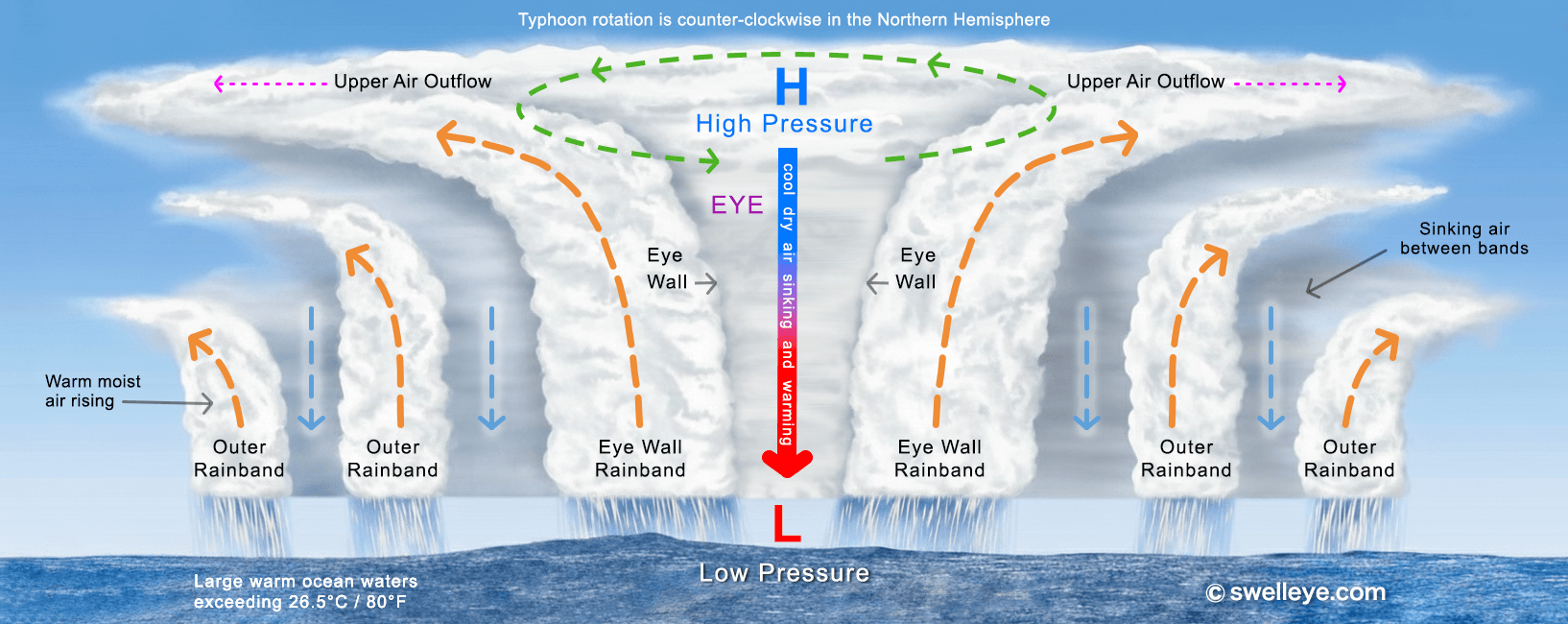
If a typhoon is expected to bring 31 mph (50 km/h, 13.9 m/s) or stronger winds to the seas within 62 miles (100 km) of Taiwan, Penghu, Kinmen, or Matsu within the next 24 hours, a sea warning will be issued right away. It will then be updated every 3 hours, or more often if needed.
If a sea warning is issued and the 31 mph (50 km/h, 13.9 m/s) or stronger wind area may affect Green Island or Lanyu, those places will also be included in the warning area.
When a sea warning has been issued, the following will display:
🌊 Sea Warning Issued ❌ 6/23, 11:11 pm
If a typhoon is expected to bring 31 mph (50 km/h, 13.9 m/s) or stronger winds to the land areas of Taiwan, Penghu, Kinmen, or Matsu within the next 18 hours, a land warning will be issued right away. It will then be updated every 3 hours, or more often if needed.
When a land warning has been issued, the following will display:
🏝️ Land Warning Issued ❌ 6/23, 11:11 pm
If a typhoon is near Taiwan, Penghu, Kinmen, or Matsu, or if it changes speed, direction, or size in a major way, officials may issue a sea warning or land warning immediately. If needed, they may issue both at the same time.
A sea warning will be lifted as soon as the 31 mph (50 km/h, 13.9 m/s) or stronger wind area moves away from the nearby seas of Taiwan, Kinmen, and Matsu.
When a sea warning has been lifted, the following will display:
🌊 Sea Warning Lifted ✓ 6/24, 6:21 am
A land warning will be lifted as soon as the 31 mph (50 km/h, 13.9 m/s) or stronger wind area moves away from the land areas of Taiwan, Penghu, Kinmen, or Matsu.
When a land warning has been lifted, the following will display:
🏝️ Land Warning Lifted ✓ 6/24, 6:21 am
If the typhoon turns away or disappears, the warning can be lifted right away.
Typhoons generate powerful, long-period swells that can transform Taiwan's surf breaks. Understanding regional impacts helps maximize sessions safely:
Swell Period & Size: Longer periods (13s+) indicate groundswell that wraps into more exposed breaks. Shorter periods (8-11s) suggest wind swell or fetch-limited conditions. Always check both size AND period for quality assessment.
Interpreting typhoon forecast data helps surfers time sessions and assess conditions. Key elements to monitor:
For Surfers: Focus on 24-72 hour windows when typhoon is 500-1000 km (300-600 miles) offshore—far enough for manageable local winds but close enough for strong swell. Avoid surfing during direct typhoon passage due to extreme winds, currents, and debris. Also be aware of the men and women in orange suits.
Typhoon swells bring exceptional surf but also serious hazards. Prioritize safety and respect local protocols:
⚠️ Remember: No wave is worth your life. Typhoon swells will come again. Make conservative decisions, surf with experienced buddies, and always have an exit strategy.
Proper equipment and preparation are essential for safely surfing typhoon-generated swells:
💡 Pro Tip: Keep a dedicated typhoon swell kit ready: backup leash, helmet, booties, first aid, and high-visibility rashguard. When forecasts show a swell window, you'll be prepared to go without scrambling for gear.


See the surf first!
See the surf first!
© Swelleye, Ltd. All rights reserved.
See the surf first!
See the surf first!
All rights reserved.