We use cookies to improve your experience on our website. Cookies help us remember your preferences,
analyze how you use our site, and provide personalized content. By clicking "Accept All," you consent
to the use of all cookies. You can also customize your cookie preferences or reject non-essential cookies.
If you are a Swelleye PRO subscriber and want to access live streams, you must enable cookies and accept at least "Strictly Necessary" cookies.
Customize Your Cookie Preferences
For more information about our cookie usage, please read our
Cookie Policy.
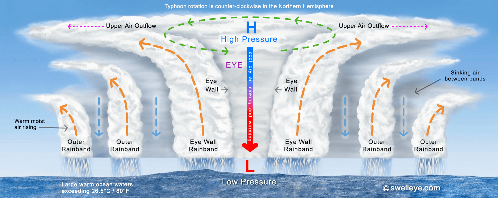
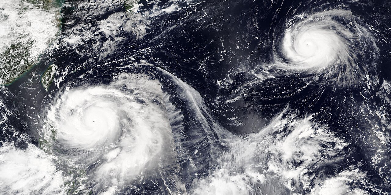
A typhoon is a tropical cyclone that forms in the Western Pacific Ocean. These powerful rotating storm systems develop over warm ocean waters (above 26.5°C / 80°F) and are characterized by:
Organized thunderstorm clusters rotating around a low-pressure center
Sustained winds of at least 74 mph (119 km/h, 33 m/s)
Counter-clockwise rotation in the Northern Hemisphere
Heavy rainfall, storm surge, and powerful ocean swells
Formation Process: Typhoons begin as tropical disturbances, intensifying through a feedback loop where warm, moist air rises and condenses, releasing heat energy that fuels further development. The Coriolis effect from Earth's rotation causes the system to spin.
The same phenomenon is called a "hurricane" in the Atlantic / Eastern Pacific and a "cyclone" in the Indian Ocean. Only the regional name differs.
Typhoon Seasons in the Western Pacific
▼
The Western Pacific has the most active typhoon basin in the world, with typhoons possible year-round and an average of 16 per year. However, activity varies by season:
Peak Season (July–October): Most frequent and intense typhoons. August and September see the highest activity.
Secondary Peak (May–June): Early season storms, often forming further south near the Philippines.
Off-Season (November–April): Reduced activity, but occasional strong systems can still develop, particularly in the southern basin.
Climate Influences: El Niño and La Niña cycles affect typhoon tracks and intensity. El Niño years tend to shift storm formation further east, while La Niña can bring more systems closer to Asia's coastlines. Long-term warming trends may also influence storm intensity and rainfall.
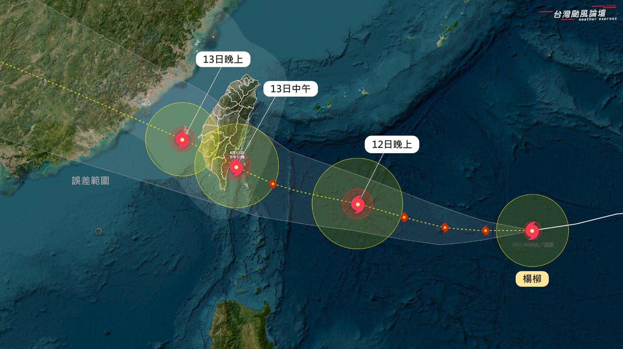
Tracks Affecting Taiwan
▼
Taiwan's position in the Western Pacific puts it directly in the path of many typhoon tracks. Common patterns include:
Westward Track: Forms east of the Philippines, moves west-northwest, crossing Taiwan or passing just south. Peak season pattern.
Recurving Track: Approaches from the south or southeast, curves northeast past Taiwan toward Japan. More common in late season (Sept–Oct).
Northern Track: Forms further east, passes north of Taiwan through the Ryukyu Islands. Still generates swell for northern coasts.
Direct Hit: Crosses Taiwan's main island, bringing extreme winds and rainfall to both coasts. Less common but highest impact.
Steering Currents: The subtropical ridge and mid-latitude westerlies influence track direction. Monitoring pressure patterns helps predict whether a typhoon will curve away or make landfall.
Typhoon Classifications
▼
Typhoons are classified by sustained wind speeds, which determine their intensity and potential impact. Understanding these categories helps assess threat levels and prepare accordingly:
International Classifications
Tropical Depression: Winds below 39 mph (63 km/h, 17 m/s). Organized circulation with potential to strengthen.
Tropical Storm: Winds 39-73 mph (63-118 km/h, 17-33 m/s). Named system with defined circulation and rain bands.
Taiwan's Central Weather Administration uses its own three-band scale for Chinese-language warnings. We translate these to Saffir-Simpson categories for English readers, but the original CWA labels are:
輕度颱風 (Tropical Storm): Winds 17-33 m/s (39-73 mph, 62-117 km/h).
中度颱風: Winds 33-51 m/s (73-114 mph, 118-183 km/h) — overlaps Category 1-3 in the English scale.
強烈颱風: Winds 51+ m/s (114+ mph, 184+ km/h) — overlaps Category 3-5 / Super Typhoon in the English scale.
For Surfers: Even tropical storms and weaker typhoons generate powerful swells. Monitor intensity forecasts to time sessions—prime surfing windows often occur 24-48 hours before arrival when swell builds but winds remain manageable.
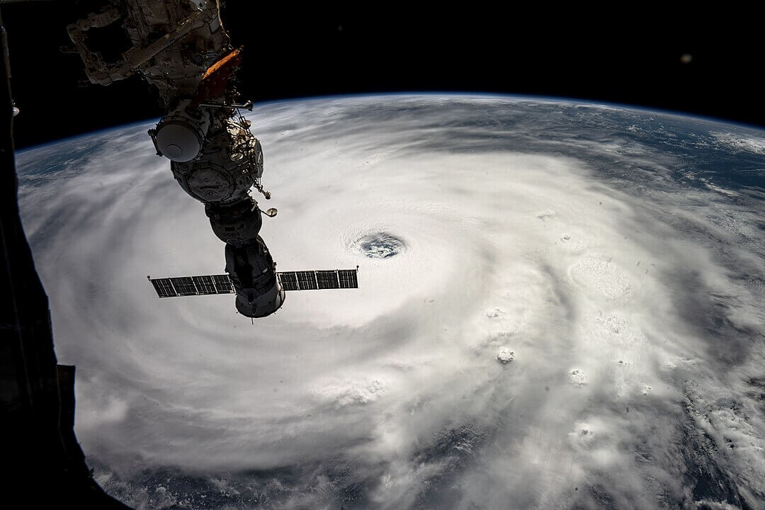
Super Typhoon Ragasa, 2025.09.22
Surf Impacts for Taiwan
▼
Typhoons generate powerful, long-period swells that can transform Taiwan's surf breaks. Understanding regional impacts helps maximize sessions safely:
East Coast (Yilan, Hualien, Taitung)
Primary Swell Window: Open to E, SE, and NE swells. First to receive typhoon energy.
Typical Size: Can reach 8-15+ ft faces with periods of 12-16s during peak swell events.
Timing: Swell arrives 24-48 hours before typhoon passage, peaks during closest approach, tapers 12-24 hours after.
Considerations: Onshore winds common during typhoon passage. Best windows often before arrival or after departure with offshore winds (ideal conditions).
Northeast Coast (Fulong, Green Bay, Jinshan)
Swell Window: NE to E exposure. Benefits from typhoons tracking north or recurving.
Bathymetry: Reef and point breaks focus energy. Can handle larger swells with better shape than beach breaks.
Wind: Offshore SW winds during post-typhoon high pressure can create firing conditions.
South Coast (Nanwan, Jialeshui)
Swell Window: S to SE swells. Better for typhoons passing south of Taiwan or approaching from the southwest.
Shadowing: Protected from northerly swells by the main island.
Season: Summer typhoons (July-Sept) more likely to send surfable swells here.
West Coast (Qijin, Yuguangdao, Songbai Harbor)
Minimal swell from typhoons due to Taiwan Strait shadowing. Primarily wind-driven waves during typhoon passage.
Swell Period & Size: Longer periods (13s+) indicate groundswell that wraps into more exposed breaks. Shorter periods (8-11s) suggest wind swell or fetch-limited conditions. Always check both size AND period for quality assessment.
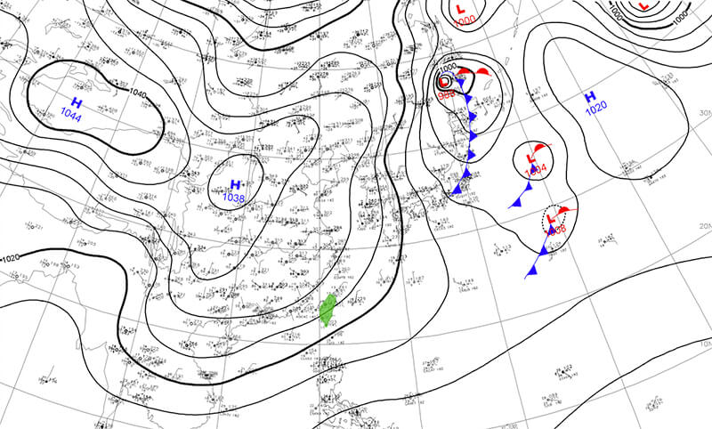
Reading Forecast Charts
▼
Interpreting typhoon forecast data helps surfers time sessions and assess conditions. Key elements to monitor:
Wind Field Analysis
Wind Speed Contours: Tighter spacing = stronger winds. Look for asymmetric patterns—swell generation strongest in the right-front quadrant (Northern Hemisphere).
Fetch Length & Duration: Long fetch aligned toward your coast + sustained winds = better swell. Check wind direction arrows for consistency.
Wind vs. Swell Direction: Winds blow from high to low pressure (clockwise around typhoon). Swell radiates outward but refracts based on bathymetry.
Pressure Systems
Central Pressure: Lower pressure = more intense typhoon. Sub-950 hPa systems are major typhoons.
For Surfers: Focus on 24-72 hour windows when typhoon is 500-1000 km (300-600 miles) offshore—far enough for manageable local winds but close enough for strong swell. Avoid surfing during direct typhoon passage due to extreme winds, currents, and debris. Also be aware of the men and women in orange suits.
Safety and Etiquette
▼
Typhoon swells bring exceptional surf but also serious hazards. Prioritize safety and respect local protocols:
Hazards to Avoid
Shorebreak: Large swells dump directly on shore, causing neck/spinal injuries. Never turn your back on the ocean.
Rip Currents: Exponentially stronger during big swells. If caught, paddle parallel to shore, don't fight the current.
Debris: Typhoons dislodge trees, trash, and sharp objects. Check lineup for floating hazards before paddling out.
Coastal Closures: Respect local authorities' beach closures and warnings. Fines and rescue costs apply for violations.
Lightning: Outer typhoon bands bring thunderstorms. Exit water immediately if lightning is within 10 km.
Know Your Limits: Typhoon swells are not the time to push beyond your skill level, and beginners should never surf them!
Wait Your Turn: Peak crowds during swell events. Respect priority, don't snake waves or drop in.
Communicate: Call off waves if you can't make them. Avoid collisions by staying visible and predictable.
Help Others: Keep an eye on struggling surfers. Be ready to assist in emergencies.
Leave No Trace: Take your trash when you leave the beach. Typhoons already bring enough debris; don't add to it.
When NOT to Surf
During typhoon passage and sustained winds 25+ mph (40+ km/h, 11+ m/s), heavy rain and/or lightning
Official warnings or closures in effect
Alone with no backup or communication. Don't surf alone during a typhoon - it's not worth the risk.
Conditions beyond your ability (honestly assess size, current, and wind)
Poor visibility (fog, heavy rain, dusk/dawn during swell peaks)
⚠️ Remember: No wave is worth your life. Typhoon swells will come again. Make conservative decisions, surf with experienced buddies, and always have an exit strategy.
Gear and Preparation
▼
Proper equipment and preparation are essential for safely surfing typhoon-generated swells:
Board Selection
Bigger Swells (8+ ft): Step up to a gun or semi-gun (7'0"-9'0"+ depending on wave size). More length = better paddling, stability, and wave catching in critical drops.
Moderate Swells (4-7 ft): Standard shortboard or fish works. Add volume if conditions are wind-affected or you need more paddle power.
Reef Breaks: Consider extra rocker and narrower tail for steep drops. Avoid soft-tops or fragile boards.
Essential Safety Gear
Leash: Use a thicker, comp/big-wave leash (7mm+) for swells over 6 ft. Check swivels and rail saver for wear before each session.
Helmet: Recommended for reef breaks. Protects against board hits and shallow impacts.
Booties: Sharp coral, rocks, and debris are prevalent post-typhoon. Reef booties provide grip and protection.
Rashguard/Wetsuit: Even in warm water, long sessions drain energy. Layer appropriately for temperature and abrasion protection.
Fin Setup
Thruster (3-fin): Typically best all-around for control and maneuverability in varied conditions.
Quad: More drive and speed in larger, hollower waves. Less directional control on steep drops.
Single/2+1: Suitable for bigger boards and point breaks. Smooth, drawn-out turns.
Fin Size: Typically the bigger the waves the smaller the fins you should use.
Pre-Session Checklist
Check Central Weather Administration (CWA), local warnings, and coastal advisories
Inspect board for dings (repair before session to avoid waterlogging)
Assess current, wind, and lineup from shore for 10+ minutes (you can do it while you stretch)
Identify exit points and hazards (rocks, rips, shallow sections)
Bring water, sunscreen, and first-aid kit to beach
Tell someone your surf plan and expected return time
Post-Session Maintenance
Rinse board and gear with fresh water immediately (saltwater + debris accelerates wear)
Check for new dings; repair promptly to prevent water damage
Dry leash and wetsuit thoroughly to avoid mold
Inspect fins for cracks or looseness
Clean wax buildup and reapply as needed
💡 Pro Tip: Keep a dedicated typhoon swell kit ready: backup leash, helmet, booties, first aid, and high-visibility rashguard. When forecasts show a swell window, you'll be prepared to go without scrambling for gear.


See the surf first!
See the surf first!
© Swelleye, Ltd. All rights reserved.
See the surf first!
See the surf first!
All rights reserved.